A tale of two fishes: how standing genetic diversity influences species responses to environmental change

How can species respond to environmental change?

If you’re a somewhat avid (or even cursory) reader of The G-CAT, you may remember my wrap-up post at the conclusion of my PhD in 2020 which described the various chapters of my thesis. Well, I’m pleased to announce that data chapter 2 of that thesis – on the comparative phylogeography of two threatened Australian freshwater fishes – has just been published in the journal BMC Ecology and Evolution. It’s a pretty complex paper which tackles genetic diversity, phylogenetics, demographic history, species distribution models and how these interact together to understand the evolutionary history of these species in a comparative framework. Feel free to check it out (it’s open access and free to read!) here.

Continue reading

From coast to continent: how our freshwater biota travelled across the landscape

The Australian aquascape

To anyone who has lived within Australia for a given period time, and likely many from across the globe, it is clear that water is a precious resource. Rainfall across much of the continent is patchy and variable, and the availability of water is a critical aspect in the distribution, survival and evolution of many Australian species. Expectedly, these aspects play an even bigger role for those taxonomic groups that heavily rely on the presence of water; freshwater-dependent taxa such as fish, amphibians or aquatic invertebrates show a keen evolutionary relationship with water across the landscape.

Continue reading

Two Worlds: contrasting Australia’s temperate regions

Temperate Australia

Australia is renowned for its unique diversity of species, and likewise for the diversity of ecosystems across the island continent. Although many would typically associate Australia with the golden sandy beaches, palm trees and warm weather of the tropical east coast, other ecosystems also hold both beautiful and interesting characteristics. Even the regions that might typically seem the dullest – the temperate zones in the southern portion of the continent – themselves hold unique stories of the bizarre and wonderful environmental history of Australia.

The two temperate zones

Within Australia, the temperate zone is actually separated into two very distinct and separate regions. In the far south-western corner of the continent is the southwest Western Australia temperate zone, which spans a significant portion. In the southern eastern corner, the unnamed temperate zone spans from the region surrounding Adelaide at its westernmost point, expanding to the east and encompassing Tasmanian and Victoria before shifting northward into NSW. This temperate zones gradually develops into the sub-tropical and tropical climates of more northern latitudes in Queensland and across to Darwin.


Labelled Koppen-Geiger map
The climatic classification (Koppen-Geiger) of Australia’s ecosystems, derived from the Atlas of Living Australia. The light blue region highlights the temperate zones discussed here, with an isolated region in the SW and the broader region of the SE as it transitions into subtropical and tropical climates northward.

The divide separating these two regions might be familiar to some readers – the Nullarbor Plain. Not just a particularly good location for fossils and mineral ores, the Nullarbor Plain is an almost perfectly flat arid expanse that stretches from the western edge of South Australia to the temperate zone of the southwest. As the name suggests, the plain is totally devoid of any significant forestry, owing to the lack of available water on the surface. This plain is a relatively ancient geological structure, and finished forming somewhere between 14 and 16 million years ago when tectonic uplift pushed a large limestone block upwards to the surface of the crust, forming an effective drain for standing water with the aridification of the continent. Thus, despite being relatively similar bioclimatically, the two temperate zones of Australia have been disconnected for ages and boast very different histories and biota.

Elevation map of NP.jpg
A map of elevation across the Australian continent, also derived from the Atlas of Living Australia. The dashed black line roughly outlines the extent of the Nullarbor Plain, a massively flat arid expanse.

The hotspot of the southwest

The southwest temperate zone – commonly referred to as southwest Western Australia (SWWA) – is an island-like bioregion. Isolated from the rest of the temperate Australia, it is remarkably geologically simple, with little topographic variation (only the Darling Scarp that separates the lower coast from the higher elevation of the Darling Plateau), generally minor river systems and low levels of soil nutrients. One key factor determining complexity in the SWWA environment is the isolation of high rainfall habitats within the broader temperate region – think of islands with an island.

SSWA environment.jpg
A figure demonstrating the environmental characteristics of SWWA, using data from the Atlas of Living AustraliaLeft: An elevation map of the region, showing some mountainous variation, but only one significant steep change along the coast (blue area). Right: A summary of 19 different temperature and precipitation variables, showing a relatively weak gradient as the region shifts inland.

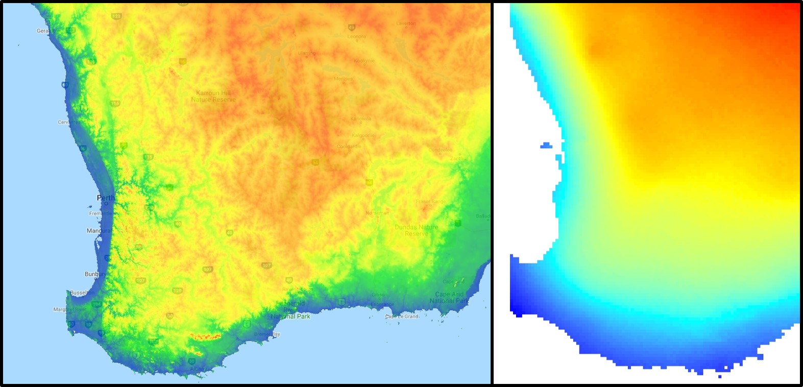
Despite the lack of geological complexity and the perceived diversity of the tropics, the temperate zone of SWWA is the only internationally recognised biodiversity hotspot within Australia. As an example, SWWA is inhabited by ~7,000 different plant species, half of which are endemic to the region. Not to discredit the impressive diversity of the rest of the continent, of course. So why does this area have even higher levels of species diversity and endemism than the rest of mainland Australia?

speciation patterns in SWWA.jpg
A demonstration of some of the different patterns which might explain the high biodiversity of SWWA, from Rix et al. (2015). These predominantly relate to different biogeographic mechanisms that might have driven diversification in the region, from survivors of the Gondwana era to the more recent fragmentation of mesic habitats.

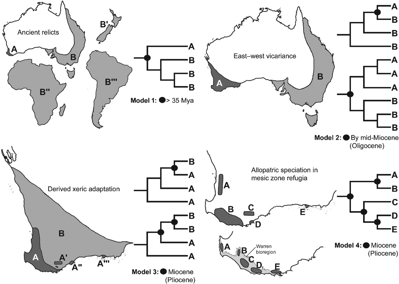
Well, a number of factors may play significant roles in determining this. One of these is the ancient and isolated nature of the region: SWWA has been separated from the rest of Australia for at least 14 million years, with many species likely originating much earlier than this. Because of this isolation, species occurring within SWWA have been allowed to undergo adaptive divergence from their east coast relatives, forming unique evolutionary lineages. Furthermore, the southwest corner of the continent was one of the last to break away from Antarctica in the dismantling of Gondwana >30 million years ago. Within the region more generally, isolation of mesic (wetter) habitats from the broader, arid (xeric) habitats also likely drove the formation of new species as distributions became fragmented or as species adapted to the new, encroaching xeric habitat. Together, this varies mechanisms all likely contributed in some way to the overall diversity of the region.

The temperate south-east of Australia

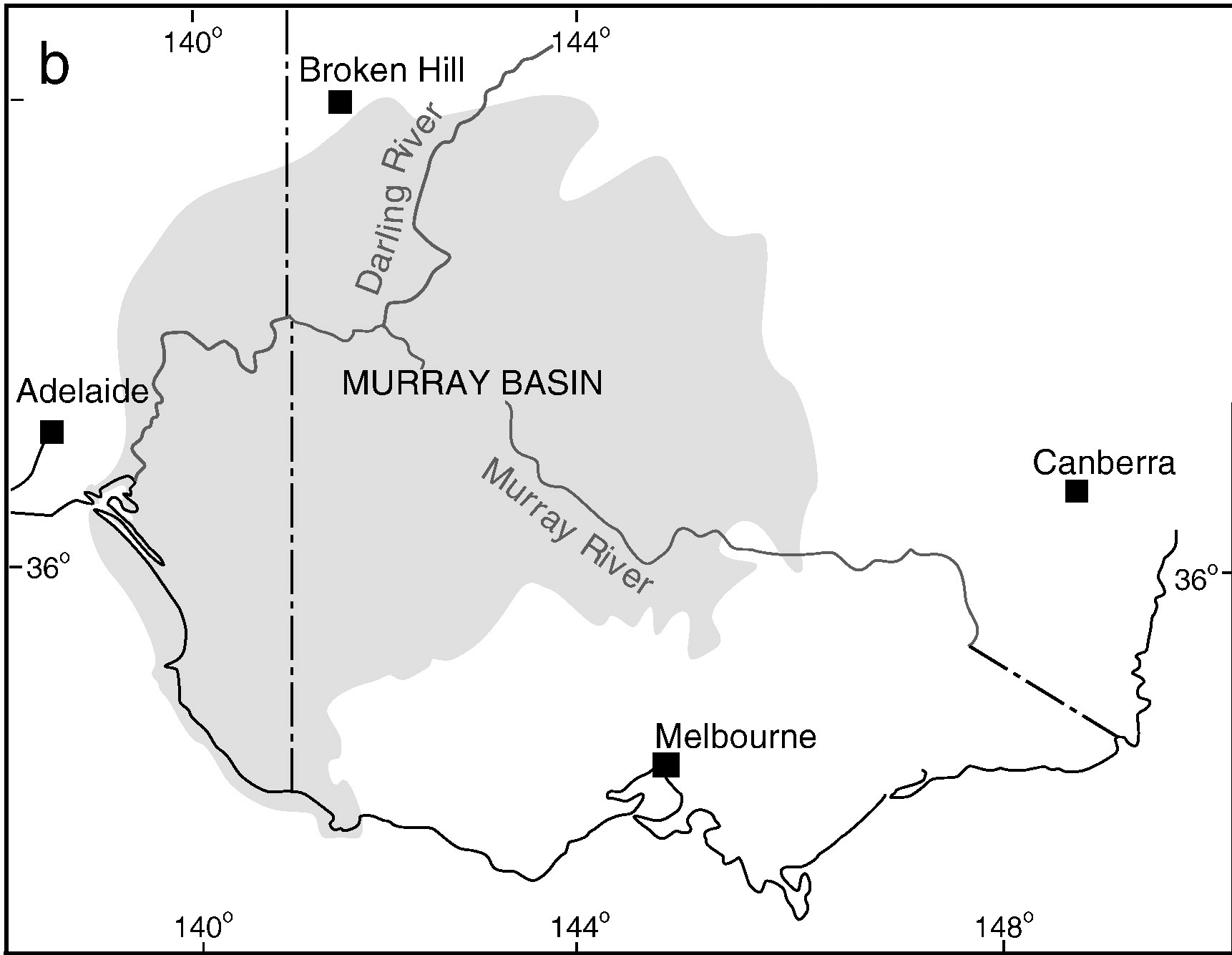
Contrastingly, the temperate region in the south-east of the continent is much more complex. For one, the topography of the zone is much more variable: there are a number of prominent mountain chains (such as the extended Great Dividing Range), lowland basins (such as the expansive Murray-Darling Basin) and variable valley and river systems. Similarly, the climate varies significantly within this temperate region, with the more northern parts featuring more subtropical climatic conditions with wetter and hotter summers than the southern end. There is also a general trend of increasing rainfall and lower temperatures along the highlands of the southeast portion of the region, and dry, semi-arid conditions in the western lowland region.

MDB map
A map demonstrating the climatic variability across the Murray-Darling Basin (which makes up a large section of the SE temperate zone), from Brauer et al. (2018). The different heat maps on the left describe different types of variables; a) and b) represent temperature variables, c) and d) represent precipitation (rainfall) variables, and e) and f) represent water flow variables. Each variable is a summary of a different set of variables, hence the differences.

A complicated history

The south-east temperate zone is not only variable now, but has undergone some drastic environmental changes over history. Massive shifts in geology, climate and sea-levels have particularly altered the nature of the area. Even volcanic events have been present at some time in the past.

One key hydrological shift that massively altered the region was the paleo-megalake Bungunnia. Not just a list of adjectives, Bungunnia was exactly as it’s described: a historically massive lake that spread across a huge area prior to its demise ~1-2 million years ago. At its largest size, Lake Bungunnia reached an area of over 50,000 km­­­2, spreading from its westernmost point near the current Murray mouth although to halfway across Victoria. Initially forming due to a tectonic uplift event along the coastal edge of the Murray-Darling Basin ~3.2 million years ago, damming the ancestral Murray River (which historically outlet into the ocean much further east than today). Over the next few million years, the size of the lake fluctuated significantly with climatic conditions, with wetter periods causing the lake to overfill and burst its bank. With every burst, the lake shrank in size, until a final break ~700,000 years ago when the ‘dam’ broke and the full lake drained.

Lake Bungunnia map 2.jpg
A map demonstrating the sheer size of paleo megalake Bungunnia at it’s largest extent, taken from McLaren et al. (2012).

Another change in the historic environment readers may be more familiar with is the land-bridge that used to connect Tasmania to the mainland. Dubbed the Bassian Isthmus, this land-bridge appeared at various points in history of reduced sea-levels (i.e. during glacial periods in Pleistocene cycle), predominantly connecting via the still-above-water Flinders and Cape Barren Islands. However, at lower sea-levels, the land bridge spread as far west as King Island: central to this block of land was a large lake dubbed the Bass Lake (creative). The Bassian Isthmus played a critical role in the migration of many of the native fauna of Tasmania (likely including the Indigenous peoples of the now-island), and its submergence and isolation leads to some distinctive differences between Tasmanian and mainland biota. Today, the historic presence of the Bassian Isthmus has left a distinctive mark on the genetic make-up of many species native to the southeast of Australia, including dolphins, frogs, freshwater fishes and invertebrates.

Bass Strait bathymetric contours.jpg
An elevation (Etopo1) map demonstrating the now-underwater land bridge between Tasmania and the mainland. Orange colours denote higher areas whilst light blue represents lower sections.

Don’t underestimate the temperates

Although tropical regions get most of the hype for being hotspots of biodiversity, the temperate zones of Australia similarly boast high diversity, unique species and document a complex environmental history. Studying how the biota and environment of the temperate regions has changed over millennia is critical to predicting the future effects of climatic change across large ecosystems.

How did pygmy perch swim across the desert?

“Pygmy perch swam across the desert”

As regular readers of The G-CAT are likely aware, my first ever scientific paper was published this week. The paper is largely the results of my Honours research (with some extra analysis tacked on) on the phylogenomics (the same as phylogenetics, but with genomic data) and biogeographic history of a group of small, endemic freshwater fishes known as the pygmy perch. There are a number of different messages in the paper related to biogeography, taxonomy and conservation, and I am really quite proud of the work.

Southern_pygmy_perch 1 MHammer
A male southern pygmy perch, which usually measures 6-8 cm long.

To my honest surprise, the paper has received a decent amount of media attention following its release. Nearly all of these have focused on the biogeographic results and interpretations of the paper, which is arguably the largest component of the paper. In these media releases, the articles are often opened with “…despite the odds, new research has shown how a tiny fish managed to find its way across the arid Australian continent – more than once.” So how did they manage it? These are tiny fish, and there’s a very large desert area right in the middle of Australia, so how did they make it all the way across? And more than once?!

 The Great (southern) Southern Land

To understand the results, we first have to take a look at the context for the research question. There are seven officially named species of pygmy perches (‘named’ is an important characteristic here…but we’ll go into the details of that in another post), which are found in the temperate parts of Australia. Of these, three are found with southwest Western Australia, in Australia’s only globally recognised biodiversity hotspot, and the remaining four are found throughout eastern Australia (ranging from eastern South Australia to Tasmania and up to lower Queensland). These two regions are separated by arid desert regions, including the large expanse of the Nullarbor Plain.

Pygmyperch_distributionmap
The distributions of pygmy perch species across Australia. The dots and labels refer to different sampling sites used in the study. A: the distribution of western pygmy perches, and essentially the extent of the southwest WA biodiversity hotspot region. B: the distribution of eastern pygmy perches, excluding N. oxleyana which occurs in upper NSW/lower QLD (indicated in C). C: the distributions relative to the map of Australia. The black region in the middle indicates the Nullarbor Plain. 


The Nullarbor Plain is a remarkable place. It’s dead flat, has no trees, and most importantly for pygmy perches, it also has no standing water or rivers. The plain was formed from a large limestone block that was pushed up from beneath the Earth approximately 15 million years ago; with the progressive aridification of the continent, this region rapidly lost any standing water drainages that would have connected the east to the west. The remains of water systems from before (dubbed ‘paleodrainages’) can be seen below the surface.

Nullarbor Plain photo
See? Nothing here. Photo taken near Watson, South Australia. Credit: Benjamin Rimmer.

Biogeography of southern Australia

As one might expect, the formation of the Nullarbor Plain was a huge barrier for many species, especially those that depend on regular accessible water for survival. In many species of both plants and animals, we see in their phylogenetic history a clear separation of eastern and western groups around this time; once widely distributed species become fragmented by the plain and diverged from one another. We would most certainly expect this to be true of pygmy perch.

But our questions focus on what happened before the Nullarbor Plain arrived in the picture. More than 15 million years ago, southern Australia was a massively different place. The climate was much colder and wetter, even in central Australia, and we even have records of tropical rainforest habitats spreading all the way down to Victoria. Water-dependent animals would have been able to cross the southern part of the continent relatively freely.

Biogeography of the enigmatic pygmy perches

This is where the real difference between everything else and pygmy perch happens. For most species, we see only one east and west split in their phylogenetic tree, associated with the Nullarbor Plain; before that, their ancestors were likely distributed across the entire southern continent and were one continuous unit.

Not for pygmy perch, though. Our phylogenetic patterns show that there were multiple splits between eastern and western ancestral pygmy perch. We can see this visually within the phylogenetic tree; some western species of pygmy perches are more closely related, from an evolutionary perspective, to eastern species of pygmy perches than they are to other western species. This could imply a couple different things; either some species came about by migration from east to west (or vice versa), and that this happened at least twice, or that two different ancestral pygmy perches were distributed across all of southern Australia and each split east-west at some point in time. These two hypotheses are called “multiple invasion” and “geographic paralogy”, respectively.

MCC_geographylabelled
The phylogeny of pygmy perches produced by this study, containing 45 different individuals across all species of pygmy perch. Species are labelled in the tree in brackets, and their geographic location (east or west) is denoted by the colour on the right. This tree clearly shows more than one E/W separation, as not all eastern species are within the same clade. For example, despite being an eastern species, N. variegata is more closely related to Nth. balstoni or N. vittata than to the other eastern species (N. australisN. obscuraN. oxleyana and N. ‘flindersi’.

So, which is it? We delved deeper into this using a type of analysis called ‘ancestral clade reconstruction’. This tries to guess the likely distributions of species ancestors using different models and statistical analysis. Our results found that the earliest east-west split was due to the fragmentation of a widespread ancestor ~20 million years ago, and a migration event facilitated by changing waterways from the Nullarbor Plain pushing some eastern pygmy perches to the west to form the second group of western species. We argue for more than one migration across Australia since the initial ancestor of pygmy perches must have expanded from some point (either east or west) to encompass the entirety of southern Australia.

BGB_figure
The ancestral area reconstruction of pygmy perches, estimated using the R package BioGeoBEARS. The different pie charts denote the relative probability of the possible distributions for the species or ancestor at that particular time; colours denote exactly where the distribution is (following the legend). As you can see, the oldest E/W split at 21 million years ago likely resulted from a single widespread ancestor, with it’s range split into an east and west group. The second E/W event, at 15 million years ago, most likely reflects a migration from east to west, resulting in the formation of the N. vittata species group. This coincides with the Nullarbor Plain, so it’s likely that changes in waterway patterns allowed some eastern pygmy perch to move westward as the area became more arid.

So why do we see this for pygmy perch and no other species? Well, that’s the real mystery; out of all of the aquatic species found in southeast and southwest Australia, pygmy perch are one of the worst at migrating. They’re very picky about habitat, small, and don’t often migrate far unless pushed (by, say, a flood). It is possible that unrecorded extinct species of pygmy perch might help to clarify this a little, but the chances of finding a preserved fish fossil (let alone for a fish less than 8cm in size!) is extremely unlikely. We can really only theorise about how they managed to migrate.

Pygmy perch biogeo history
A diagram of the distribution of pygmy perch species over time, as suggested by the ancestral area reconstruction. A: the initial ancestor of pygmy perches was likely found throughout southern Australia. B: an unknown event splits the ancestor into an eastern and western group; the sole extant species of the W group is Nth. balstoniC: the ancestor of the eastern pygmy perches spreads towards the west, entering part of the pre-Nullarbor region. D: due to changes in the hydrology of the area, some eastern pygmy perches (the maroon colour in C) are pushed towards the west; these form N. vittata species and N. pygmaea. The Nullarbor Plain forms and effectively cuts off the two groups from one another, isolating them.

What does this mean for pygmy perches?

Nearly all species of pygmy perch are threatened or worse in the conservation legislation; there have been many conservation efforts to try and save the worst-off species from extinction. Pygmy perches provide a unique insight to the history of the Australian climate and may be a key in unlocking some of the mysteries of what our land was like so long ago. Every species is important for conservation and even those small, hard-to-notice creatures that we might forget about play a role in our environmental history.

Not that kind of native-ity: endemism and invasion of Australia

The endemics of Australia

Australia is world-renowned for the abundant and bizarre species that inhabit this wonderful island continent. We have one of the highest numbers of unique species in the entire world (in the top few!): this is measured by what we call ‘endemism’. A species is considered endemic to a particular place or region if that it is the only place it occurs: it’s completely unique to that environment. In Australia, a whopping 87% of our mammals, 45% of our birds, 93% of our reptiles, 94% of our amphibians 24% of our fishes and 86% of our plants are endemic, making us a real biodiversity paradise! Some lists even label us as a ‘megadiverse country’, which sounds pretty awesome on paper. And although we traditionally haven’t been very good at looking after it, our array of species is a matter of some pride to Aussies.

Endemism map
A map representing the relative proportion of endemic species in Australia, generated through the Atlas of Living Australia. The colours range from no (white; 0% endemics) or little (blue) to high levels of endemism (red; 100% of species are endemic). As you can see, some biogeographic hotspots are clearly indicated (southwest WA, the east coast, the Kimberley ranges).

But the real question is: why are there so many endemics in Australia? What is so special about our country that lends to our unique flora and fauna? Although we naturally associate tropical regions with lush, vibrant and diverse life, most of Australia is complete desert. That said, most of our species are concentrated in the tropical regions of the country, particularly in the upper east coast and far north (the ‘Top End’).

There are a number of different factors which contribute to the high species diversity of Australia. Most notably is how isolated we are as a continent: Australia has been separated from most of the rest of the world for millions of years. In this time, the climate has varied dramatically as the island shifted northward, creating a variety of changing environments and unique ecological niches for species to specialise into. We refer to these species groups as ‘Gondwana relicts’, since their last ancestor with the rest of the world would have been distributed across the supercontinent Gondwana over 100 million years ago. These include marsupials, many birds groups (including ratites and megapodes), many fish groups and a plethora of others. A Gondwanan origin explains why they are only found within Australia, southern Africa and South America (the closest landmass that was also historically connected to Gondwana).

Early arrivals and naturalisation to the Australian ecosystem 

But not all of Australia’s species are so ancient and ingrained in the landscape. As Australia drifted northward and eventually collided with the Sunda plate (forming the mountain ranges across southeast Asia), many new species and groups managed to disperse into Australia. This includes the first indigenous people to colonise Australia, widely regarded as one of the oldest human civilisations and estimated to have arrived down under over 65 thousand years ago.

Eventually, this connection also brought with them one of our most iconic species; the dingo. Estimates of their arrival dates the migration at around 6 thousand years ago. As Australia’s only ‘native’ dog, there has been much debate about its status as an Australian icon. To call the dingo ‘native’ implies it’s always been there: but 6 thousand years is more than enough time to become ingrained within the ecosystem in a stable fashion. So, to balance the debate (and prevent the dingo from being labelled as an ‘invasive pest’ unfairly), we often refer to them as ‘naturalised’. This term helps us to disentangle modern-day pests, many of which our immensely destructive to the natural environment, from other species that have naturally migrated and integrated many years ago.

Patriotic dingo
Although it may not be a “true native”, the dingo will forever be a badge of our native species pride.

Invaders of the Australian continent

Of course, we can never ignore the direct impacts of humans on the ecosystem. Particularly with European settlement, another plethora of animals were introduced for the first time into Australia; these were predominantly livestock animals or hunting-related species (both as predators and prey). This includes the cane toad, widely regarded as one of the biggest errors in pest control on the planet.

When European settlers in the 1930s attempted to grow sugar cane in the far eastern part of the country, they found their crops decimated by a local beetle. In an effort to eradicate them, they brought over a species of cane toad, with the idea that they would control the beetle population and all would be well. Only, cane toads are particularly lazy and instead of targeting the cane beetles, they just thrived on all the other native invertebrates around. They’re also very resilient and adaptable (and highly toxic), so their numbers exploded and they’ve since spread across a large swathe of the country. Their toxic skin makes them fatal food objects for many native predators and they strongly compete against other similar native animals (such as our own amphibians). The cane toad introduction of 1935 is the poster child of how bad failed pest control can be.

DSC_0867_small
This guy here, he’s a bastard. Spotted in my parent’s backyard in Ipswich, QLD. Source: me, with spite.

But is native always better?

History tells a very stark tale about the poor native animals and the ravenous, rampaging pest species. Because of this, it is a widely adopted philosophical viewpoint that ‘native is always best’. And while I don’t disagree with the sentiment (of course we need to preserve our native wildlife, and not the massively overabundant pests), there are rare examples where nature is a little more complicated. In Australia, this is exemplified in the noisy miner.

The noisy miner is a small bird which, much like its name implies, is incredibly noisy and aggressive. It’s highly abundant, found predominantly throughout urban and suburban areas, and seems to dominate the habitat. It does this by bullying out other bird species from nesting grounds, creating a monopoly on the resource to the exclusion of many other species (even larger ones such as crows and magpies). Despite being native, it seems to have thrived on human alteration of the landscape and is a serious threat to the survival and longevity of many other species. If we thought of it solely under the ‘nature is best’ paradigm, we would dismiss the noisy miner as ‘doing what it should be.’ The truth is really more of a philosophical debate: is it natural to let the noisy miner outcompete many other natives, possibly resulting in their extinction? Or is it only because of human interference (and thus is our responsibility to fix) that the noisy miner is doing so well in the first place? It’s not a simple question to answer, although the latter seems to be incredibly important.

Noisy miner harassing currawong
An example of the aggressive behaviour of the noisy miner (top), swooping down on a pied currawong (bottom). Despite the size differences, noisy miners will frequently attempt to harass and scare off other larger birds. Image source: Bird Ecology Study Group website.

The amazing biodiversity of Australia is a badge of honour we should wear with patriotic pride. Conservation efforts of our endemic fauna are severely limited by a lack of funding and resources, and despite a general acceptance of the importance of diverse ecosystems we remain relatively ineffective at preserving it. Understanding and connecting with our native wildlife, whilst finding methods to control invasive species, is key to conserving our wonderful ecosystems.