The Australian aquascape
To anyone who has lived within Australia for a given period time, and likely many from across the globe, it is clear that water is a precious resource. Rainfall across much of the continent is patchy and variable, and the availability of water is a critical aspect in the distribution, survival and evolution of many Australian species. Expectedly, these aspects play an even bigger role for those taxonomic groups that heavily rely on the presence of water; freshwater-dependent taxa such as fish, amphibians or aquatic invertebrates show a keen evolutionary relationship with water across the landscape.
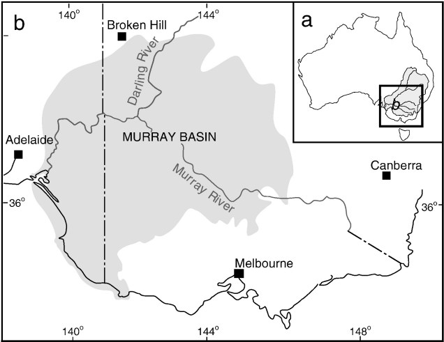
As a landscape, Australia is ancient. The vast majority of our mountain ranges developed millions of years ago, and tectonically Australia has been (relatively) stable over millennia (especially compared to other regions closer to fault lines). This combination of stable topography and water variability across a continental scale leads to large-scale patterns and divisions of waterbodies. These are commonly referred to as ‘drainage basins’, which are defined by the way water accumulates into particular depressions across the landscape. Some notable examples of drainage basins in Australia include the Murray-Darling Basin (MDB), which covers a staggering 1,061,000 km2 (~14% of the Australian mainland area) and provides up to 3,780 gigalitres per year of water for agriculture. Despite it’s ecological and anthropogenic importance, the MDB is but one of ~13 major drainage basins across Australia, and only the 4th largest!

The distribution of freshwater biodiversity
Given the relatively ancient and stable nature of this drainage basins, they often form defining aspects of the extent or range of the distribution of freshwater species. In some cases, a species may occur in only one (or part of one) drainage basin, isolated from others by mountain ranges, oceanic water or other unsuitable habitat characteristics. But for many others, the full distribution of the species occurs across multiple drainage basins, spreading across a wider area and over seemingly impassable barriers. Instead of forming new isolated species, the divides between these drainages act to delineate populations or groups of populations within the species.

From marine to freshwater
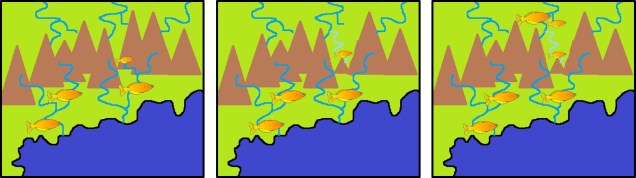
For a large number of freshwater species, research has indicated that their ancestors were likely marineancestors were likely marine. Australia has been isolated from other continents for a very long time, so this makes sense: even if species had existed in the landscape, they would have needed to survive with limited water availability for tens of millions of years. Instead, we find many of the groups of freshwater species that occur in Australia likely arrived across the ocean more recently. From their coastal habitats, they gradually colonised inland river systems, adapting to a new freshwater environment and spreading throughout the riverscape. As part of this process, they lost their marine tolerance ability and become one with the freshwater ecosystem.
What this means for their biogeographic patterns is that many species would have initially occurred in the coastal basins around the continent. But we know many of species occur further inland, and indeed some of these are the more biodiverse regions. So how do they colonise the coast and then move into inland basins, across these seemingly insurmountable barriers of drainage divides?
How does movement occur across drainages?
River capture by tectonic rearrangement
Despite maps showing drainage boundaries as somewhat discrete, linear sections, there is a degree of gray area surrounding them. This is because topographic barriers like mountains are neither 100% stable over time nor perfectly flat boundaries, and so are susceptible to changes. For example, when small tectonic shifts occur over even short time frames, minor alterations to the shape and structure of mountain ranges may cause water flowing down the landscape to alter in direction. Sometimes, these alterations can significantly change the riverscape enough that some rivers flow in entirely opposite directions to their original trajectory. This process is termed ‘river capture’, and has been suggested numerous times in the past as a mechanism for ‘pushing’ species across drainage divides as the redirected water carries organisms via new pathways.
Shifting waterbodies by tectonics or aridity
Edges of drainages are not always defined by the presence of a mountain range. In some cases, areas with low current rainfall create plains-like regions where water does not noticeably drain in any particular direction. This phenomenon, however, might also not be the long-term normal for the area: sometimes, these areas are the remains of once-present waterbodies which connected large swathes of rivers together. One example we’ve looked at before is the paleo-megalake Bungunnia in southeast Australia, which spanned a whopping 90,000 km2 at its largest extent. Some (as yet unpublished) results from my PhD indicates that this lake (and its demise) was a significant factor in the spread and isolation of populations of a small endemic freshwater fish. Other studies have also suggested this role for other species too.
Changing sea levels
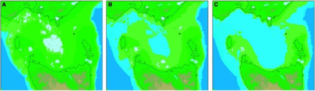
Although less relevant for basins occurring further inland, marine water also acts as a defining ‘edge’ for coastal basins. As we know, though, sea levels are not totally static over time and have fluctuated in accordance with climate in the past. In some cases, the lowered sea levels of glacial maxima connected currently-isolated landmasses, such as Tasmania and continental Australia. The formation of a ‘land-bridge’ between what would now be considered isolated basins similarly may have facilitated the transfer of terrestrial and freshwater lineages onto some island ecosystems.
Evidence from genetic studies
So, how do we know that many freshwater species had a marine ancestor, and that they travelled inland across these drainage divides? Well, predominantly from genetic analysis. While there a couple of different approaches to handling both this kind of data and question (such as using phylogenetic vs. coalescent methods), these analyses typically involve a couple important components. Firstly, estimating the timing of divergences across the different populations of the species (or across different species in a closely related group) and seeing how these relate to changes in the environment. This provides a timeframe for when these splits occurred, and assessing how well these correspond to the (independently estimated) timing of certain geological, hydrological or environmental events may shed light on the mechanisms underlying these patterns.

For movement across drainage divides in Australia, genetic studies suggesting inter-basin migration have been conducted for a wide variety of taxa. A quick search of the literature finds examples such as crayfish, several different fish species and frogs. These vary in their dispersal ability and many other biological traits; although these could (and indeed should) influence the likelihood and strength of geographic barrier across the distribution, we see that even some animals which are naturally poor dispersers demonstrate movement.
In some cases where we might want to be a little more explicit with our testing, we can apply simulation modelling techniques using the coalescent to compare how likely each factor is in driving the (genetic) patterns we see. By understanding what events have occurred in the past, we can make predictions about how these should have impacted the distribution of genetic diversity across the species or populations. We then run simulations of the genetic diversity under these models, compare them to our empirical genetic data, and determine which of these various scenarios makes the most sense.
The various studies across the Australian continent suggest that a variety of factors could be important in driving how, or if, species move across drainage divides. One of the most notable of these in river capture; despite the apparent topographical changes across basins, drainage divides in Australia often have relatively little elevation difference and even small changes (e.g. due to minor tectonic activity) can potentially make rivers flow in different directions. Sometimes, this might carry freshwater species across boundaries, and help them distribute across the landscape.
Studies like these are important for predicting how distributions may (or may not!) change in accordance with climate change, and understanding how and why freshwater species occur where they do. Although aspects of the environment like rainfall and temperature undoubtedly play principle roles in the survival and evolution of species, some species in some areas may never get the chance to respond by moving to new favourable habitats without the right conduit.

One thought on “From coast to continent: how our freshwater biota travelled across the landscape”