The structure of a river system
For anyone who has had to study geography at some point in their education, you’d likely be familiar with the idea of river courses drawn on a map. They’re so important, in fact, that they are often the delimiting factor in the edges of countries, states or other political units. Water is a fundamental requirement of all forms of life and the riverways that scatter the globe underpin the maintenance, structure and accumulation of a large swathe of biodiversity.
So, what is a river?
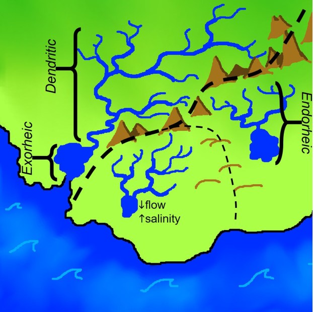
Typically, a river starts as water is collected from rainfall at higher elevations (such as mountain ranges). As the water collects, it travels downhill (due to gravity): as it progresses, a number of streams can connect together to form larger unified bodies of waters. This hierarchical system of rivers, with streams connected in a tree-like shape, is called a dendritic system. If a system of rivers (referred to as a ‘drainage basin’) flows out to an ocean it is called exorheic: if it ends in a terminal lake (often called ‘closed lakes’) or simply evaporates at the lowest part of the basin, it is endorheic. All of these aspects play a role in how the river system is shaped (particularly in how water flows and nutrients/sediments accumulate). Related to this concept, the influence of water flow on salinity is a strong determinant in what lakes within a system look like (comparing a freshwater lake with Lake Eyre, for example).
Steady like a river?
One drawback with this idea of a ‘mapped’ river system is the idea that rivers are static and unchanging over time. This leads to the implicit assumption that, given that we know where a river is today, we can always reliably predict where it has been. But this is undoubtedly not the case, and occurs frequently across the globe. Rivers can frequently change their course, direction and terminus in response to a number of different environmental factors that control the overall dynamics of the system.
Just around the river bend
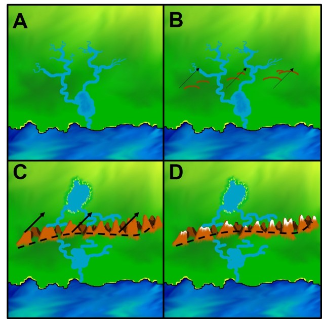
Some of these alterations are caused by tectonic shifts: movement of the continental plates over history causes the landscape to uplift or subside in response to pressures placed on them by neighbouring plates. This is the driving force that generates mountain ranges, but it’s also not static or changing over time. Since rivers naturally tend to follow the path of least resistance (directly aided by gravity), even small shifts in topography can cause a river to wildly redirect and change course. Other factors that could influence the shape of rivers include climate (having more or less water available can shrink/grow lakes and isolate or reconnect different rivers), or of course human alterations through damming or deliberate redirection of rivers.
You probably get the idea that the world has, and will continue, to change dramatically with the environment. But what does this mean for life on Earth? Well, a large number of freshwater species are strongly limited by their reliance on available freshwater: dispersal across land without water is incredibly difficult or rare, and many taxa move in accordance with river flow and turbidity. Furthermore, secondary impacts from a change in water velocity such as the accumulation of soil, turbidity of the system and formation of ponds and lakes can significantly alter the available preferred habitat for many specialist species. For Australian readers, the recent debacle of the mismanagement of the Murray-Darling Basin and the mass fish kills at Menindee Lakes are one (rather horrific) example of the consequences of human-induced river alteration.
So what does this mean for landscapes that are more susceptible to river changes?
Water on the driest continent
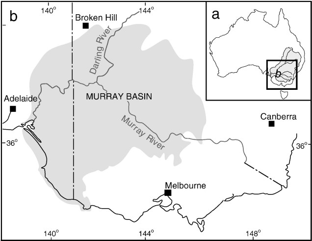
As you might have guessed, the Australian continent is a great example of this. Australia is, on the whole, a generally flat continent. Topographic variation across much of the landscape is low and even our mountain ranges (such as the Great Dividing Range, which covers much of the east coast) is relatively low compared to many other iconic ranges on Earth. By this nature, small changes in the topography or elevation in parts of Australia have had huge impacts on the way our environment is shaped. Because of this, river systems are highly variable over the history and the borders between drainage basins can be obscured or blurry.
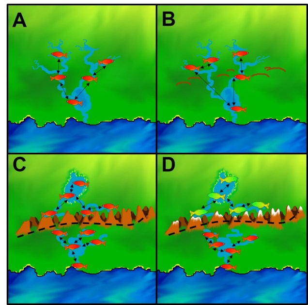
A key example of this drove the formation (and eventual demise) of the paleolake Bungunnia. Believe it or not, back in the Pliocene (>~3 million years ago; Mya) the Murray River exited into the ocean much further east than its current location, running off ~340 km away from the modern mouth. For many species that occupied freshwater habitats south of the Great Dividing Range, the ancestral Murray River was an important conduit between the two major basins of the Murray-Darling (MDB) and southwest Victoria (SWV). This is how a large number of freshwater species spread from their coastal origins and colonised the inland habitats.

However, a large tectonic event ~3 Mya caused an uplift event along a part of the range called the Padthaway High, right where the ancestral Murray used to flow (along a gorge named the Douglas Depression). This uplift broke the connection of the Murray River to the ocean, causing all the freshwater run-off the basin to collect within the inland area. With no outlet, and a large flat expanse of area, the water collected into a lake 90,000 km2 at its largest: a mighty beast we know call Lake Bungunnia. For comparison, Australia’s current largest lake, Lake Eyre, reaches a maximum of 9,690 km2 – just over a tenth of Lake Bungunnia.
So where did it all go? Well, the actual size of Lake Bugunnia fluctuated quite a lot of the following years: cycles of climate change from glacial (wet, in Australia) and interglacial (arid) periods caused a series of overfilling events, where the lake burst it’s banks and eroded the edges. During the arid periods, the lake reduced in size, until the next glacial cycle where it burst again. This happened a number of times over the ~2.5 Mya of its life until a final bursting event ~700,000 years ago drained the last of the water. This burst occurred near the current border of South Australia and Victoria; unsurprisingly, where the current Murray River mouth is (and the remnants of Lake Bungunnia can be seen in Lake Alexandrina and Lake Albert).
For a number of freshwater species, including turtles, fishes and invertebrates, Lake Bungunnia and the breaking of the ancestral Murray caused large evolutionary splits within species, and has even been attributed to the divergence and formation of new species. Undoubtedly, the role of Lake Bungunnia in determining patterns of species and genetic diversity and differentiation is clear. Isolation of lineages is a critical aspect of allopatric speciation, and this is well-represented by the evolution of Murray-Darling Basin.
The reshaped water
Understanding the role the historic aquatic environment has played in shaping the evolution of freshwater species is important for projecting climate change. With increasing aridity, significant alterations to natural waterways and growing demand for freshwater, we must always consider the ecological and broad-scale environmental impacts of our decisions.
